This past weekend I wandered down to the Moab, Utah area with a friend of mine (Gordon) to meet with my brother and his family - who'd arrived the day before - to do some hiking.
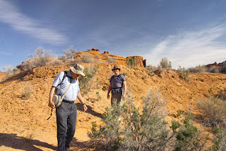 |
Figure 1:
Gordon and my brother, just entering the wash near
the bridge. |
We weren't really considering doing anything too serious so after a bit of thought I suggested Lower Courthouse Wash which lies almost entirely within Arches National Park. I'd done this hike at least three times in the past - but not since the mid 1990's - and I knew it to be a nice walk along sandy embankments, occasionally through the cool water flowing over and through large sand bars and embankements - except near the end where the joint grass and trees got thicker, occasionally requiring one to walk through the watercourse to avoid having to push through the thickets. Starting from an innocuous bridge along the main road in the park, the end of the trail puts the hiker next the main highway, only a few hundred feet from the Colorado River bridge at the north end of town.
That was the plan, anyway.
Leaving home at exactly 4 AM, we drove down and met my brother and his family in Moab for breakfast at the Jailhouse Diner after which we dropped off my Jeep at a convenient parking lot along the Moab cycle trail fairly near the exit of Courthouse wash. Piling into the other car, we entered the park, drove to the bridge - which now sported a small, paved turnoff for parking - and Gordon, my brother and I wandered off down into the wash.
Right away I could tell that it was quite different - but I couldn't place exactly how: It had, after all, been nearly 20 years since I'd been there. It seemed to me that it was greener, somehow, much more vegetation.
Walking downstream I soon realized that this place had changed!
The large-ish, older cottonwood trees were expected, but I was surprised to see that many places where there had once been sand banks were now colonized by a myriad of smaller plants, rabbit brush and the occasional Russian olive tree.
It wasn't until we were about 1/2 mile downstream until we were required to make a stream crossing. By brother went first into the nearly hip-deep water, managing to cross successfully to the other side, using the conveniently-placed log and the vegetation on the opposite bank as a handhold. I went next, also making a successful crossing. Remaining to cross was Gordon who got more than halfway across and suddenly disappeared up to his neck and doing a quick backstroke. Unfortunately, there was thick vegetation between the bank closest to him and us and we couldn't safely reach him, so all we could do is watch while he managed to stagger backwards to the felled log, pull himself to his feet and then get within safe reach.
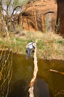 |
Figure 2:
Gordon's first tentative steps into the
water - just before a splash. |
Emptying his pockets, and handing their contents to us, I quickly removed the batteries from his digital camera while poured the water out if it, also shaking it out of the memory card and every other available orifice on the camera in an effort to minimize what was already likely to be fatal damage to its mechanism. Moving down-canyon a short distance to some rocks, we poured several inches of water out of his day pack, separated the now-ruined boxes of raisins and other food - likely contaminated by waterborne bacteria and parasites like giardia - from that which was protected in watertight containers or still dry by virtue of having been near the top and removed the batteries from other electronic items. The pack was turned inside-out, the wet clothing (jacket, extra shirt) was attached to the pack, and some of the remaining "un-soaked" items were then carried by my brother and I while the pack would dry in the now-increasing breeze blowing up the wash.
"How long do you think it will take for it to dry out?" Gordon asked. "About 15-20 minutes, I think" I replied.
Continuing down the wash, we made a few other crossings, but none so deep or dramatic, most being no more than calf-deep, but the realization that this place had transformed dramatically since I'd last been there was still dawning on me.
 |
Figure 3:
Once a wide, sandy wash, young trees and
vegetation now rule! |
I finally realized how much when we got to a right-hand turn in the stream that I'd recognized as being where I'd ended up waist-deep in quicksand last time I was there, having to hand my gear to one of the fellow hikers while I rolled out if the sand and onto firm ground. While a fairly barrent sand bar before, it was now heavily grown up with small trees and heavy brush while the watercourse - which had been those years ago, a wet area of sand - was a rather narrow channel of slow-moving water greenish through the vegetation.
Another mile or so down the wash, I looked at Gordon's pack and decreed that it will take another 15-20 minutes for it to dry to which the response was that it had been more than that last time the subject had been brought up. I pointed out, however, that it all depended on when, exactly, one started timing - and that I wouldn't know that until it was fully dry.
 |
Figure 4:
Cascades over sandstone in lower Courthouse Wash. |
Pushing through the ever-thickening brush, we made another knee-deep stream crossing through dark, tannin and algae-stained water and climbed onto a large platform of rock in order to circumvent a nearly impenetrable stand of vegetation - unless, of course, one wanted to wade through slow-moving, slick-bottomed water channel. Atop the rocks, we sat down for lunch and reassembled Gordon's now (mostly) dry pack. Briefly putting in the battery, we tried his camera - but it showed no signs of life.
By this time, the partly-cloudy sky of the morning had changed to one that was overcast while the wind blowing up from the bottom of the wash became quite brisk. The temperature was, perhaps, in the low-mid 70's and while resting, it was getting to be quite cool, but not intolerably so even though I was wearing shorts. Finishing our lunch, we continued on our way downstream, having to make the occasional knee-deep crossing.
Another mile or two brought us to some familiar territory - a series of cascades over sandstone in a wide portion of the canyon. Nearby were some very large overhangs that we decided to explore, noting that not only were they suitably large and situated for camping, but a large amount of charcoal evidence indicated that we weren't the first ones with this idea!
A short distance down from this the wash made a sharp turn to the left, requiring us to wade through calf-deep water which immediately became thigh-deep if one paused for more than a second and sunk into the submerged quicksand. Proceeding downstream from this we saw that there was difficulty ahead: The channel narrowed considerably, deepened, and footing became precarious. Getting back on dry ground, I put my boots back on, put down my day pack and set out to see if I could find an alternative route.
 |
Figure 5:
Confirmation of inhabitation
by beavers! |
As suspected, the channel got much deeper and probing with a stick showed that it had a rather soft bottom and was likely above the waist - assuming that one didn't sink into quicksand or slip and fall in! Moving farther downstream, I spotted two logs crossing the stream - a bit too wobbly and precarious for either my brother or I to attempt a crossing, but all around us were knawed-off stumps and felled trees that not only confirmed our suspicions that beavers were about, but provided us with the raw materials to bolster the bridge and allow us to cross with relative confidence that we would make it without having to go for a swim in the still, dark green water.
Continuing on, we made our way down the wash with increasing difficulty, having to cross the stream multiple times and then find a route through occasionally-thick brush. Up to this point I had been mostly barefoot, but became painfully aware of a lot small thorns in the ground litter that had occasionally required that I stop and scrape the bottom of my feet with my knife to dislodge it. Although the going was a bit slow, it turned out that the worst was behind us!
 |
Figure 6:
One of, perhaps, a dozen beaver dams of
various sizes that we saw. This was one of the
last seen before reaching the highway. |
As we continued, the clouds thickened and the wind picked up. It occurred to us that we were, in fact, in a wash that drained a large chunk of Arches National Park and the surrounding area and that being there with increasing clouds probably wasn't the most ideal situation - this notion being occasionally reinforced by the fact that we could often see the remains of past flash floods wrapped around trees at heights that placed the water level as being 6-8 feet above the wash bottom! Since the clouds looked rather benign and the forecast didn't indicate rain until the late evening, we weren't too terribly worried.
A few more miles brought us to the exit of the wash, a fact reinforced by the fact that ahead, we started catching glimpses of more-distant canyon walls. Another sure sign of being near the end of the trail is that we also started seeing the occasional beer can and cigarette butt - neither items being frequently seen very far from where one might park a vehicle!
 |
Figure 7:
Informative sign at the bottom of Courthouse Wash.
If you click on the image and inspect the picture
on the sign, you will see what much of lower
Courthouse wash used to look like! |
Soon, the tell-tale roar of traffic greeted our ears and the bridge hove into view. This, too, had changed much since the last time I had hiked lower Courthouse Wash: The bridge was now much larger and taller and included the Moab bike trail - which had not even existed back then! Making the short walk back to the Jeep, we scraped the layers of mud off our feet and legs, pulled out a few pesky thorns and then headed back into town to drop off my brother after which Gordon and I decided to do a few short hikes in Arches before sunset.
The upshot:
I would by lying if I said that I wasn't a bit disappointed in what lower Courthouse wash has become in the nearly 20 years since I'd last hiked it. When I was done, I was nostalgic for the times that I'd made this same hike - mostly in bare feet - while walking along the wide, sandy wash bottom in the sun while the ankle-deep clear water trickled playfully downstream.
I also realize that things change over time and that in nature - as in life - such change is inevitable. It's difficult to say whether or not this course was "better" 20 or so years ago when it was much more open and, perhaps, somewhat barren: To be sure, compared to then, life positively abounds in lower Courthouse Wash - but it is distinctly less friendly to hikers!
In doing a bit of quick research on the web - and in my recollection of the book Desert Solitaire by Ed Abbey in which he talks a bit about this same area - it's easy to find documented change in this - and other - areas of red-rock country. From what I can gather, there was a tremendous flash flood through Courthouse Wash in the mid-late 1960's and, possibly, subsequent burning of much of the debris and it was likely the tail-end of this last major "cleaning" that I had enjoyed in the 1990's. Now, nature has once again recolonized an area that tantalizes with a fairly reliable source of water - a precious rarity in the desert!
Afterward:
After drying for a few days, Gordon's camera - an old Canon A80 - showed signs of life. After another week of drying out, it seems to have returned to normal operation with no apparent spots of water in the optics or mechanical problems of any sort! In the months since, he has take quite a few pictures with no obvious, recurring problems.
[End]
This page stolen from ka7oei.blogspot.com


